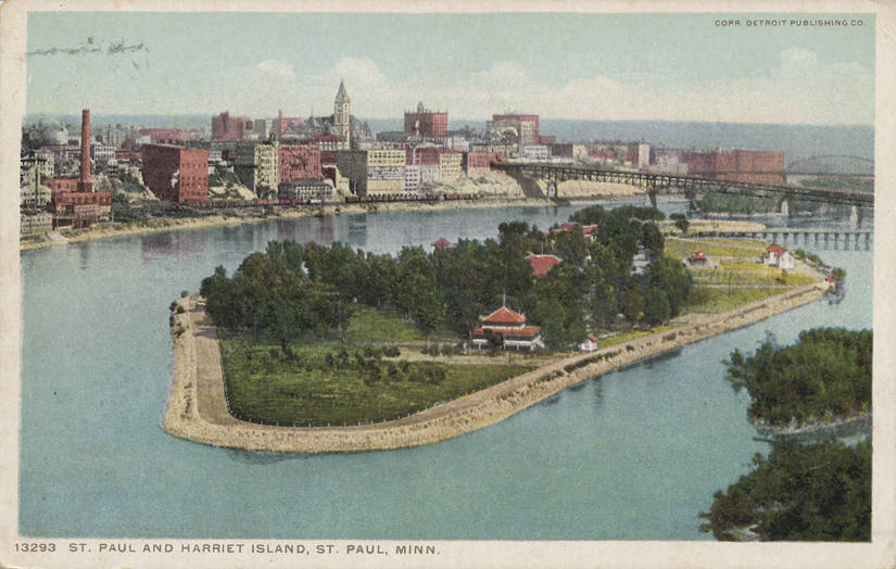
The land known today as Harriet Island was formerly sacred Dakota land named Wakan Wita (Sacred Island). Located just upriver from Wakan Tipi (Carver's Cave), another sacred site, it was deemed home to spirits. When European settlers made their way into St. Paul, they began calling the site Devil's Island, mistranslating the Dakota "Wakan" as "Satanic." At some point in the last half of the 19th century, the island was informally named Harriet Island, likely becoming formal nomenclature after island owner Dr. Justus Ohage donated the land to the city in May 1900.
For the Dakota, Wakan Wita functioned as a strategic crossroads within the broader river valley. Positioned near the confluence of the Mississippi and Minnesota rivers, the island served as a key site for fishing, travel, and the harvesting of wild rice. Its significance was not merely subsistence-based; its immediate proximity to Wakan Tipi tied the island to a larger sacred geography.
The Dakota's hold on Wakan Wita broke with the construction of Fort Snelling. Anchored at the confluence of the Mississippi and Minnesota rivers, the fort became the pressure point for the Treaty of 1837, which forced the Dakota to cede all lands east of the Mississippi. Since the river's main channel ran west of Wakan Wita, the island fell legally outside Dakota control. Sacred use became precarious, then impossible. The military tightened its grip in 1840, evicting all "squatters" from the Fort Snelling reservation and forcing them downriver — directly into the area of Pig's Eye (later St. Paul) and the island itself.
A naming dispute persisted throughout the rest of the 19th century. While local newspapers were already identifying the site as "Harriet Island" in reports as early as 1866, official cartography was slower to adapt. In 1874, regional maps finally added the third name — honoring Minnesota Territory's first schoolteacher, Harriet Bishop — alongside the existing labels. Though the previous two names remained on maps, "Harriet Island" gained currency as the city of St. Paul matured.
In October 1899, St. Paul Health Commissioner Dr. Justus Ohage Sr. purchased the remainder of the island at tax sale, consolidating the parcels. The German-born physician had recently observed "Germanic Bath Culture" during a return trip to his homeland, a model combining bathing facilities with laundry services and medical treatment. He envisioned St. Paul's riverfront as ideal for similar preventative health infrastructure — baths for the working class, laundry for the city's poor, and a first aid and emergency station. Construction began that month.
The island opened to the public on May 26, 1900. That same day, Dr. Ohage transferred the deed for "Harriet Island" to the city of St. Paul, stipulating that "the institution should always be managed by the Health Department without political interference, and … it should be conducted solely as a place of wholesome recreation, free of money-making amusement features."
River sewage and industrial pollution put an end to beachgoing by 1920, and the years that followed only made things worse. By the late 1920s, the stench rising from the water on a hot summer day was nearly unbearable. Before 1933, there was no wastewater treatment; discharges were piped directly into the river. As the Mississippi grew more polluted, fewer people visited the island. The deterioration had become so severe that in 1935 Dr. Ohage threatened to reclaim the land he had deeded to the city decades earlier.
Officials agreed that changing times would not allow the park to return to its initial hygienic vision. Fully aware of the resource they had, the city began taking steps to preserve the civic character of the land. Events continued on the island, though none involved water from the river. In 1941, the park's architectural gravity was restored with the construction of a new limestone pavilion designed by Clarence "Cap" Wigington, the nation's first African American municipal architect.
In 1949, to create a 9-foot deep navigation channel capable of handling modern barge traffic, the U.S. Army Corps of Engineers (St. Paul District) cut the north bank of the island. By 1950, the channel separating the island from the West Side was filled in with dredged material — a convenient dumping ground for the cubic yards of sediment being pulled from the river. Harriet Island became an island in name only.
After decades hidden behind warehouses and industrial buildings, the 21st century brought a return to prominence. A $15 million Saint Paul Riverfront Redevelopment project cleared the industrial blight, restored the Wigington Pavilion, and added the Target Stage for large-scale public events. In a final tribute to the man who secured the land's future, the Ohage Great Lawn was dedicated on May 26, 2000, surrounding a monument to Dr. Justus Ohage near the entrance.